

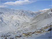
Azerbaijan is in the South Caucasus region of Eurasia, straddling Western Asia and Eastern Europe. Three physical features dominate Azerbaijan: the Caspian Sea, whose shoreline forms a natural boundary to the east; the Greater Caucasus mountain range to the north; and the extensive flatlands at the country's center. The total length of Azerbaijan's land borders is 2,648 km (1,645 mi), of which 1007 are with Armenia, 756 with Iran, 480 with Georgia, 390 with Russia and 15 with Turkey.[46] The coastline stretches for 800 km (497 mi), and the length of the widest area of the Azerbaijani section of the Caspian Sea is 456 km (283 mi).[46] The territory of Azerbaijan extends 400 km (249 mi) from north to south, and 500 km (311 mi) from west to east. The three mountain ranges are the Greater and Lesser Caucasus, and the Talysh Mountains, together covering approximately 40% of the country.[47] The highest peak of Azerbaijan is mount Bazardüzü (4,466 m), while the lowest point lies in the Caspian Sea (-28 m). Nearly half of all the mud volcanoes on Earth are concentrated in Azerbaijan.
The main water sources are the surface waters. However, only 24 of the 8,350 rivers are greater than 100 km (62 mi) in length.[47] All the rivers drain into the Caspian Sea in the east of the country.[47] The largest lake is Sarysu (67 km²), and the longest river is Kur (1,515 km), which is transboundary. Azerbaijan's four main islands in the Caspian Sea have a combined area of over thirty square kilometres.
Orography

Azerbaijan is home to a vast variety of landscapes. Over half of Azerbaijan's land mass consists of mountain ridges, crests, yailas and plateaus which rise up to hypsometric levels of 400-1000 meters (including the Middle and Lower lowlands), in some places (Talis, Jeyranchol-Ajinohur and Langabiz-Alat foreranges) up to 100-120 metres, and others from 0 - 50 meters and up (Qobustan, Absheron). The rest of Azerbaijan's terrain consist of plains and lowlands. Hypsometric marks within the Caucasus region vary from about -28 metres at the Caspian Sea shoreline up to 4466 metres, (Bazardüzü peak).[48]
Climate


The formation of climate in Azerbaijan is influenced particularly by cold arctic air masses of Scandinavian anticyclone, temperate of Siberian anticyclone, and Central Asian anticyclone.[49] Azerbaijan's diverse landscape affects the ways air masses enter the country.[49] The Greater Caucasus protects the country from direct influences of cold air masses coming from the north. That leads to the formation of subtropical climate on most foothills and plains of the country. Meanwhile, plains and foothills are characterized by high solar radiation rates.
Nine out of eleven existing climate zones are present in Azerbaijan.[50] Both the absolute minimum temperature ( −33 °C/−27.4 °F ) and the absolute maximum temperature ( 46 °C/114.8 °F ) were observed in Julfa and Ordubad.[50] The maximum annual precipitation falls in Lankaran (1,600 to 1,800 mm) and the minimum in Absheron (200 to 350 mm).[50]
Flora
Azerbaijan has a very rich flora, more than 4,500 species of higher plants have been registed in the country. Due the unique climate in Azerbaijan, the flora is much richer in the number of species than the flora of the other republics of the South Caucasus. About 67% of the species growing in the whole Caucasus can be found in Azerbaijan.
The richness of Azerbaijan's flora and the variety of its vegetation results from the variety and richness of its physical-geographic and natural-historic conditions and from its compound history influenced by the remote floristic regions.
Fauna
The first reports on the richness and diversity of animal life in Azerbaijan can be found in travel notes of Eastern travelers. Animal carvings on architectural monuments, ancient rocks and stones survived up to the present times. The first information on the animal kingdom of Azerbaijan was collected during the visits of naturalists to Azerbaijan in 17th century. Unlike fauna, the concept of animal kingdom covers not only the types of animals, but also the number of individual species.
There are 106 species of mammals, 97 species of fish, 363 species of birds, 10 species of amphibians and 52 species of reptiles which have been recorded and classified in Azerbaijan.
The symbol of Fauna in Azerbaijan is the Karabakh horse which is a mountain-steppe racing and riding horse which can only be found in Azerbaijan. The Karabakh horse has a reputation for its good temper, speed, elegance and intelligence. It is one of the oldest breeds, with ancestry dating to the ancient world. The horse was originally developed in the Azerbaijani Karabakh region in the 5th century and is named after it.[51]
Rivers and lakes

Rivers and lakes form the principal part of the water systems of Azerbaijan, they were formed over a long geological timeframe and changed significantly throughout that period. This is particularly evidenced by remnants of ancient rivers found throughout the country. The country's water systems are continually changing under the influence of natural forces and human introduced industrial activities. Artificial rivers (canals) and ponds are a part of Azerbaijan's water systems.
There are 8,359 rivers of various lengths within Azerbaijan. Of them 8,188 rivers are less than 25 kilometers in length. Only 24 rivers are over 100 kilometers long.
The Kura and Aras are the most popular rivers in Azerbaijan, they run through the Kura-Aras Lowland. The rivers that directly flow into the Caspian Sea, originate mainly from the north-eastern slope of the Major Caucasus and Talysh Mountains and run along the Samur-Devechi and Lenkeran lowlands.
From the water supply point, Azerbaijan is below the average in the world with approximately 100,000 m³/year of water per km².[50] All big water reservoirs are built on Kur. The hydrography of Azerbaijan basically belongs to the Caspian Sea basin.
Protection

Since the independence of Azerbaijan in 1991, the Azerbaijani government has taken drastic measures to preserve the environment of Azerbaijan. But national protection of the environment started to truly improve after 2001 when the state budget increased due to new revenues provided by the Baku-Tbilisi-Ceyhan pipeline. Within four years protected areas doubled and now make up eight percent of the country's territory.
Since 2001 the government has set up seven large reserves and almost doubled the sector of the budget earmarked for environmental protection.

No comments:
Post a Comment